Spatial data governance for proof-ready GIS layers.
Spatial data governance becomes stronger when accepted geometry, metadata boundaries, version history, and export evidence are designed before a dataset is written.
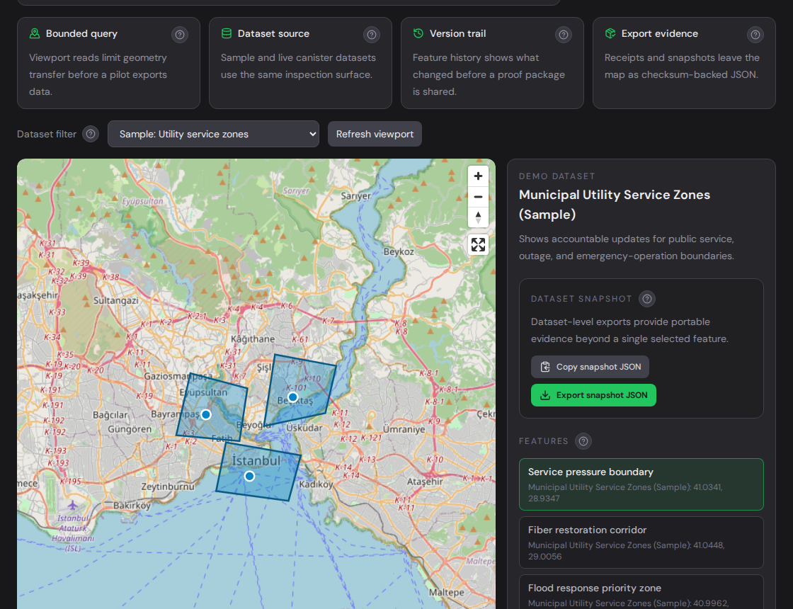
Live product surface on terminode.io: bounded map reads, feature history, proof context, and portable evidence.
InspectionCurrent and previous versions
Record modelDatasets, features, versions
EvidenceReceipts, snapshots, exports
IntegrationCandid, GeoJSON, MCP
Problem
Spatial decisions often outlive the map screen.
A boundary on a map is rarely just a drawing. It may define a service area, claim region, asset corridor, delivery rule, restricted zone, or operational decision.
The hard part is not only drawing that geometry. The hard part is proving which version was accepted, when it changed, and which evidence package can be reviewed later.
Current industry approach
Existing GIS tools remain essential, but proof workflows are often external.
Traditional GIS platforms are strong at editing, cartography, basemaps, routing, search, dashboards, and field workflows. TermiNode is not intended to replace those systems.
The missing piece is often evidence. Screenshots, exports, tickets, database logs, and shared folders can all describe part of the story, but they usually separate the accepted geometry from the audit trail.
Need
Common GIS stack
TermiNode proof layer
Edit and visualize geometry
Primary tool
Receives accepted records for proof workflows
Track accepted versions
Often app-specific
Dataset and feature history are core objects
Prepare review evidence
Manual bundle of exports and screenshots
Snapshot checksum, proof receipt, and export package
Agent-readable audit context
Usually custom integration work
Read-only MCP inspection path
Accountability gap
The gap appears when teams know a layer matters but have not defined who can import it, which metadata is safe, what proof is required, and who archives evidence.
A spatial audit trail becomes important when records cross teams or systems. One group updates a boundary; another relies on that boundary for an operational or customer-facing decision.
Without a shared proof layer, the reviewer has to rebuild context from several systems. That slows technical due diligence, dispute review, procurement, support, and partner integration.
TermiNode approach
Geometry history and proof receipts belong around the same record.
TermiNode adds a verifiable records layer beside the GIS and business systems teams already use. It focuses on accepted datasets, feature versions, bounded GeoJSON reads, audit events, proof receipts, and exportable evidence.
The result is a practical GIS accountability workflow: the source application can prove what happened in its domain, while TermiNode helps prove where the record belongs and which geometry was accepted.
Versioned geometry
Feature updates preserve reviewable history instead of silently overwriting the accepted state.
Proof receipts
High-value checks receive portable proof references that can be linked to spatial records.
Evidence export
Snapshots, feature evidence, checksums, and receipt JSON can be archived for review.
Bounded reads
Viewport, bbox, and paginated reads keep integration predictable.
Technical architecture
TermiNode combines workspace readiness, safe metadata, bounded reads, proof receipts, and MCP-readable context around the accepted spatial state.
The live product runs on the Internet Computer. The frontend asset canister serves terminode.io; the spatial, oracle, ledger, and governance canisters carry the product state and operational logic.
Developers can evaluate the product through the DApp, Candid calls, GeoJSON exports, TypeScript actors, REST/OGC adapter evidence, and a read-only MCP server for agent workflows.
Prepare safe metadataKeep private payloads outside TermiNode and include only references, hashes, receipt IDs, schema names, and review status.
Validate geometryStart with EPSG:4326 GeoJSON or WKB and fix rejected geometry before writing.
Write accepted recordsCreate a dataset, import a small feature set, and update one feature to prove version history.
Read and export evidenceUse bounded reads, feature versions, audit events, snapshot checksums, and proof receipts.
Add agent reviewUse MCP only for read-only inspection after records exist.
Real-world use cases
This is not one niche. The common need is reviewable spatial records.
Municipal GIS, utility GIS, infrastructure GIS, insurance GIS, logistics GIS, compliance zones, field evidence, asset regions, and blockchain applications can all reach the same point: a spatial record needs to be reviewed later.
The first pilot should still stay narrow: one dataset, one proof question, one version update, one receipt, and one export package.
TermiNode makes spatial accountability easier to inspect.
spatial data governance is useful when a map layer needs more than visualization. TermiNode helps teams preserve accepted geometry, verify proof context, export evidence, and give developers a controlled integration path.
The GIS workflow includes proof receipts, audit trails, versioned geometry, bounded reads, evidence export, MCP support, and ICP canister infrastructure.